Having never seen the charts for the weather leading to an explosive eruption I can not say catagorically that I am looking at one now but I have never seen a chart like this on:I hope we are wrong but I don't think so. Good luck to all don't miss the warnings of tornadoes across the planet. Keep your faith up and your heads down.
https://data.consumer-digital.api.metoffice.gov.uk/v1/surface-pressure/colour/2023-11-17T0000/FSXX00T_00.gif
it looks to be full of thunder With black arcs in the spiral of what appears to Popocatapetl but the forecast goes on to show Iceland.
Ah well all I can do is put a marker here and hope for the best.
A massive anticyclone is feeding what I take to be Nevado del Ruis and Pinatubo which "signal" is displaced to the south of Greenland. If there is anyone on here that is stupid enough to be following me on here you have as much faith as I do, you idiot.
Call on Jehovah he is waiting to hear from you.
On Friday, November 17, 2023 at 12:05:43 PM UTC, Mike wrote:idiot. I hope we are wrong but I don't think so. Good luck to all don't miss the warnings of tornadoes across the planet. Keep your faith up and your heads down.
Having never seen the charts for the weather leading to an explosive eruption I can not say catagorically that I am looking at one now but I have never seen a chart like this on:
https://data.consumer-digital.api.metoffice.gov.uk/v1/surface-pressure/colour/2023-11-17T0000/FSXX00T_00.gif
it looks to be full of thunder With black arcs in the spiral of what appears to Popocatapetl but the forecast goes on to show Iceland.
Ah well all I can do is put a marker here and hope for the best.
A massive anticyclone is feeding what I take to be Nevado del Ruis and Pinatubo which "signal" is displaced to the south of Greenland. If there is anyone on here that is stupid enough to be following me on here you have as much faith as I do, you
Call on Jehovah he is waiting to hear from you.17th November: 6.7M. 16 mi WSW of Burias, Philippines 2023-11-17 08:14:13 (UTC
19th November and Mar Sol Earth align as Venus Sol Mercury Align https://www.fourmilab.ch/cgi-bin/Solar?di=E292D288DA43CB4632D0045D07FDE119DCF29BA4B4DEA54EA333A8CAF51D141761726613751A27BC2022AF13B1233A6BFCE4BFBF1D31318CD18399636F5EDA2BB76ED26EF8C516700BD5E78A22BF2BF0
Problems:
This is what I imagine a real eruption would start looking like: Low-953 between Greenland and Norway
https://data.consumer-digital.api.metoffice.gov.uk/v1/surface-pressure/colour/2023-11-17T1200/FSXX12T_120.gif
On Friday, November 17, 2023 at 10:36:09 PM UTC, Mike wrote:idiot. I hope we are wrong but I don't think so. Good luck to all don't miss the warnings of tornadoes across the planet. Keep your faith up and your heads down.
On Friday, November 17, 2023 at 12:05:43 PM UTC, Mike wrote:
Having never seen the charts for the weather leading to an explosive eruption I can not say catagorically that I am looking at one now but I have never seen a chart like this on:
https://data.consumer-digital.api.metoffice.gov.uk/v1/surface-pressure/colour/2023-11-17T0000/FSXX00T_00.gif
it looks to be full of thunder With black arcs in the spiral of what appears to Popocatapetl but the forecast goes on to show Iceland.
Ah well all I can do is put a marker here and hope for the best.
A massive anticyclone is feeding what I take to be Nevado del Ruis and Pinatubo which "signal" is displaced to the south of Greenland. If there is anyone on here that is stupid enough to be following me on here you have as much faith as I do, you
direction.Call on Jehovah he is waiting to hear from you.17th November: 6.7M. 16 mi WSW of Burias, Philippines 2023-11-17 08:14:13 (UTC
19th November and Mar Sol Earth align as Venus Sol Mercury Align https://www.fourmilab.ch/cgi-bin/Solar?di=E292D288DA43CB4632D0045D07FDE119DCF29BA4B4DEA54EA333A8CAF51D141761726613751A27BC2022AF13B1233A6BFCE4BFBF1D31318CD18399636F5EDA2BB76ED26EF8C516700BD5E78A22BF2BF0
Problems:Popocatépetl (Central Mexico): Explosive activity continues. Volcanic Ash Advisory Center (VAAC) Washington warned about a volcanic ash plume that rose up to estimated 22000 ft (6700 m) altitude or flight level 220 and is moving at 20 kts in W
This is what I imagine a real eruption would start looking like: Low-953 between Greenland and Norway
https://data.consumer-digital.api.metoffice.gov.uk/v1/surface-pressure/colour/2023-11-17T1200/FSXX12T_120.gif
OCNL VA EMS. to 22000 ft (6700 m)an anticyclone. This is Sunday or rather what's was this Sunday last midnight; forecast for t+120 hours. https://data.consumer-digital.api.metoffice.gov.uk/v1/surface-pressure/colour/2023-11-18T1200/FSXX12T_120.gif
Nevado del Ruiz (Colombia): Explosive activity continues. Volcanic Ash Advisory Center (VAAC) Washington warned about a volcanic ash plume that rose up to estimated 22000 ft (6700 m) altitude or flight level 220 .
NEW VA OBSD to 22000 ft (6700 m)
Sangay (Ecuador): Explosive activity continues. Volcanic Ash Advisory Center (VAAC) Washington warned about a volcanic ash plume that rose up to estimated 22000 ft (6700 m) altitude or flight level 220 .
CONS VA EMS. to 22000 ft (6700 m)
Also ran:
Reventador (Ecuador): Explosive activity continues. Volcanic Ash Advisory Center (VAAC) Washington warned about a volcanic ash plume that rose up to estimated 17000 ft (5200 m) altitude or flight level 170 and is moving at 10 kts in SE direction.
FRQT VA EMS. to 17000 ft (5200 m)
Sabancaya (Peru): Volcanic Ash Advisory Center Buenos Aires (VAAC) issued the following report: continuous ash emissions
Fuego (Guatemala): Explosive activity continues. Volcanic Ash Advisory Center (VAAC) Washington warned about a volcanic ash plume that rose up to estimated 15000 ft (4600 m) altitude or flight level 150 and is moving at 5 kts in SW direction.
VA EM OBSD to 15000 ft (4600 m)
Beginnings of the time of distress. As in heaven also upon earth?
I have no idea the worst is yet to come by Wednesday/Thursday, I think. Low-955 with eyes widening from the Middle of the Atlantic just south of the Arctic through the Baltic states. Three eruptions. Be they Reykjavik or something else pushed North by
I won't be able to get the afternoon forecast until gone 9pm tonight. Not that it should make any difference, this all being supposition.continues
22 thousand feet is 4 miles 3 1/2 nautical miles, so not too exceptional.
I wish these idiots would all convert to Earth Units like God intended instead of this satanic californcation so prevalent these days.
One last look before postage:
North Atlantic Low-976 breaking with <6.8M earthquake Noon Thursday with output from an accompanying volcanic eruption likely Popocatapetl or the suspected Icelandic. New Low formed over Russia 972 Noon Friday 24th November 2023; volcanic activity
https://data.consumer-digital.api.metoffice.gov.uk/v1/surface-pressure/colour/2023-11-19T1200/FSXX12T_120.gif
Jehovah bless us one and all and protect us from the machinations of man made/demonic interference with fire out of heaven.
https://www.fourmilab.ch/cgi-bin/Solar?di=6818580250C941CCB85A8ED78D776B935678112E3E542FC429B922407F949093EEFFE19EF89D9016EEA0709DB61490A5703CB888B7C8836D7B4B4DD5C59F079D1DA302D9526FA5F40BE24D172288ACE90194
Or maybe not as the case may be see Venus Sol Mercury Pluto well you can't be too careful and we know they are not helping; the reason being if they can thwart Jehovah's coming Armageddon, they will be dead not slaves: Genesis 9:
Cursed be canaan let him be the lowest of.... https://www.qwant.com/?client=brz-vivaldi&q=Cursed+be+canaan+jw.org&t=web
On Sunday, November 19, 2023 at 11:36:32 PM UTC, Mike wrote:idiot. I hope we are wrong but I don't think so. Good luck to all don't miss the warnings of tornadoes across the planet. Keep your faith up and your heads down.
On Friday, November 17, 2023 at 10:36:09 PM UTC, Mike wrote:
On Friday, November 17, 2023 at 12:05:43 PM UTC, Mike wrote:
Having never seen the charts for the weather leading to an explosive eruption I can not say catagorically that I am looking at one now but I have never seen a chart like this on:
https://data.consumer-digital.api.metoffice.gov.uk/v1/surface-pressure/colour/2023-11-17T0000/FSXX00T_00.gif
it looks to be full of thunder With black arcs in the spiral of what appears to Popocatapetl but the forecast goes on to show Iceland.
Ah well all I can do is put a marker here and hope for the best.
A massive anticyclone is feeding what I take to be Nevado del Ruis and Pinatubo which "signal" is displaced to the south of Greenland. If there is anyone on here that is stupid enough to be following me on here you have as much faith as I do, you
direction.Call on Jehovah he is waiting to hear from you.17th November: 6.7M. 16 mi WSW of Burias, Philippines 2023-11-17 08:14:13 (UTC
19th November and Mar Sol Earth align as Venus Sol Mercury Align https://www.fourmilab.ch/cgi-bin/Solar?di=E292D288DA43CB4632D0045D07FDE119DCF29BA4B4DEA54EA333A8CAF51D141761726613751A27BC2022AF13B1233A6BFCE4BFBF1D31318CD18399636F5EDA2BB76ED26EF8C516700BD5E78A22BF2BF0
Problems:Popocatépetl (Central Mexico): Explosive activity continues. Volcanic Ash Advisory Center (VAAC) Washington warned about a volcanic ash plume that rose up to estimated 22000 ft (6700 m) altitude or flight level 220 and is moving at 20 kts in W
This is what I imagine a real eruption would start looking like: Low-953 between Greenland and Norway
https://data.consumer-digital.api.metoffice.gov.uk/v1/surface-pressure/colour/2023-11-17T1200/FSXX12T_120.gif
by an anticyclone. This is Sunday or rather what's was this Sunday last midnight; forecast for t+120 hours. https://data.consumer-digital.api.metoffice.gov.uk/v1/surface-pressure/colour/2023-11-18T1200/FSXX12T_120.gifOCNL VA EMS. to 22000 ft (6700 m)
Nevado del Ruiz (Colombia): Explosive activity continues. Volcanic Ash Advisory Center (VAAC) Washington warned about a volcanic ash plume that rose up to estimated 22000 ft (6700 m) altitude or flight level 220 .
NEW VA OBSD to 22000 ft (6700 m)
Sangay (Ecuador): Explosive activity continues. Volcanic Ash Advisory Center (VAAC) Washington warned about a volcanic ash plume that rose up to estimated 22000 ft (6700 m) altitude or flight level 220 .
CONS VA EMS. to 22000 ft (6700 m)
Also ran:
Reventador (Ecuador): Explosive activity continues. Volcanic Ash Advisory Center (VAAC) Washington warned about a volcanic ash plume that rose up to estimated 17000 ft (5200 m) altitude or flight level 170 and is moving at 10 kts in SE direction.
FRQT VA EMS. to 17000 ft (5200 m)
Sabancaya (Peru): Volcanic Ash Advisory Center Buenos Aires (VAAC) issued the following report: continuous ash emissions
Fuego (Guatemala): Explosive activity continues. Volcanic Ash Advisory Center (VAAC) Washington warned about a volcanic ash plume that rose up to estimated 15000 ft (4600 m) altitude or flight level 150 and is moving at 5 kts in SW direction.
VA EM OBSD to 15000 ft (4600 m)
Beginnings of the time of distress. As in heaven also upon earth?
I have no idea the worst is yet to come by Wednesday/Thursday, I think. Low-955 with eyes widening from the Middle of the Atlantic just south of the Arctic through the Baltic states. Three eruptions. Be they Reykjavik or something else pushed North
continuesI won't be able to get the afternoon forecast until gone 9pm tonight. Not that it should make any difference, this all being supposition.
22 thousand feet is 4 miles 3 1/2 nautical miles, so not too exceptional. I wish these idiots would all convert to Earth Units like God intended instead of this satanic californcation so prevalent these days.
One last look before postage:
North Atlantic Low-976 breaking with <6.8M earthquake Noon Thursday with output from an accompanying volcanic eruption likely Popocatapetl or the suspected Icelandic. New Low formed over Russia 972 Noon Friday 24th November 2023; volcanic activity
progress eastward, potentially impacting Thanksgiving travel with a series of severe thunderstorms, heavy rains, and snowfall anticipated to hit the central and eastern regions of the country early next week.https://data.consumer-digital.api.metoffice.gov.uk/v1/surface-pressure/colour/2023-11-19T1200/FSXX12T_120.gifhttps://watchers.news/2023/11/19/nws-warns-of-rapidly-changing-weather-conditions-across-the-u-s-impacting-thanksgiving-travel/
Jehovah bless us one and all and protect us from the machinations of man made/demonic interference with fire out of heaven.
https://www.fourmilab.ch/cgi-bin/Solar?di=6818580250C941CCB85A8ED78D776B935678112E3E542FC429B922407F949093EEFFE19EF89D9016EEA0709DB61490A5703CB888B7C8836D7B4B4DD5C59F079D1DA302D9526FA5F40BE24D172288ACE90194
Or maybe not as the case may be see Venus Sol Mercury Pluto well you can't be too careful and we know they are not helping; the reason being if they can thwart Jehovah's coming Armageddon, they will be dead not slaves: Genesis 9:
Cursed be canaan let him be the lowest of.... https://www.qwant.com/?client=brz-vivaldi&q=Cursed+be+canaan+jw.org&t=web
https://watchers.news/wp-content/uploads/2023/11/us-wch-november-19-20-2023-870x443.webp Sunday, November 19, 2023
us wch november 19 - 20 2023
A vigorous cold front is currently sweeping across the western United States, bringing a mix of high-elevation snow, coastal and valley rains, and strong winds, as reported by the National Weather Service. This weather pattern is expected to rapidly
The western United States is currently experiencing the onset of a vigorous upper-level trough, as forecasted by the National Weather Service (NWS).Sunday, November 19, 2023.
This system, making landfall on the West Coast, is triggering a range of severe weather conditions. The Pacific Northwest is the first to face the brunt of this system, with coastal rains, high-elevation snow, and strong gusty winds starting today,
As the cold front associated with this trough moves inland, it is expected to bring sharply falling temperatures across the Intermountain West and the Great Basin by tonight (LT). In response to these conditions, wind-related advisories have beenissued in several areas.
Simultaneously, a low pressure system is developing over the central High Plains. This system is gaining strength from the upper trough’s eastward movement. Showers and thunderstorms, already forming ahead of this low pressure area, are predicted toexpand east and northeast in the coming days.
The central Rockies and High Plains are likely to experience prolonged mountain snows and lower-elevation rains through Monday and into Monday night. The severity of the weather is expected to escalate by Monday, November 20, especially in the DeepSouth, as a warm front lifts northeastward, drawing warm, moist air from the Gulf of Mexico.
As the storm system progresses, the National Weather Service forecasts that by Tuesday morning, November 21, the low pressure center will reach the Ohio Valley. This will result in widespread rainfall extending from the lower Great Lakes down to theinterior Southeast. Thunderstorms could reach severe levels across the Mid-South and possibly the central Gulf Coast, as the dynamic cold front continues its eastward sweep.
This evolving weather pattern poses a significant risk for travel disruptions, particularly as millions of Americans prepare for Thanksgiving travel.to remain mostly dry until Tuesday morning, when the leading edge of the Ohio Valley storm’s moisture arrives.
In addition to these developments, colder air from Canada is expected to introduce a light wintry mix in the upper Midwest by early Tuesday. Interior New England is also anticipating an arctic front today into tonight. However, the East Coast is likely
Temperature variations will be notable across different regions: seasonable on the East Coast, slightly below average in New England, and mild over the northern Plains. In contrast, the West will experience below-average temperatures following thepassage of the upper trough, with coastal areas maintaining near-seasonable highs.
The National Weather Service advises residents and travelers across the affected regions to stay informed and prepare for rapidly changing weather conditions. Travelers are especially urged to plan ahead and anticipate potential delays and disruptions.State and local authorities are likely to issue additional advisories and safety information as the situation evolves. The public is encouraged to monitor local weather updates and heed any warnings or advisories issued.
References: 1 Short Range Forecast Discussion – NWS Weather Prediction Center College Park MD – 300 AM EST Sun Nov 19 2023
USA North Atlantic Forecasts: https://www.weathercharts.org/north-atlantic-mslp.htm Apparently they hold better archives but I have never been able to fathom them.
On Monday, November 20, 2023 at 7:43:30 AM UTC, Mike wrote:you idiot. I hope we are wrong but I don't think so. Good luck to all don't miss the warnings of tornadoes across the planet. Keep your faith up and your heads down.
On Sunday, November 19, 2023 at 11:36:32 PM UTC, Mike wrote:
On Friday, November 17, 2023 at 10:36:09 PM UTC, Mike wrote:
On Friday, November 17, 2023 at 12:05:43 PM UTC, Mike wrote:
Having never seen the charts for the weather leading to an explosive eruption I can not say catagorically that I am looking at one now but I have never seen a chart like this on:
https://data.consumer-digital.api.metoffice.gov.uk/v1/surface-pressure/colour/2023-11-17T0000/FSXX00T_00.gif
it looks to be full of thunder With black arcs in the spiral of what appears to Popocatapetl but the forecast goes on to show Iceland.
Ah well all I can do is put a marker here and hope for the best.
A massive anticyclone is feeding what I take to be Nevado del Ruis and Pinatubo which "signal" is displaced to the south of Greenland. If there is anyone on here that is stupid enough to be following me on here you have as much faith as I do,
direction.Call on Jehovah he is waiting to hear from you.17th November: 6.7M. 16 mi WSW of Burias, Philippines 2023-11-17 08:14:13 (UTC
19th November and Mar Sol Earth align as Venus Sol Mercury Align https://www.fourmilab.ch/cgi-bin/Solar?di=E292D288DA43CB4632D0045D07FDE119DCF29BA4B4DEA54EA333A8CAF51D141761726613751A27BC2022AF13B1233A6BFCE4BFBF1D31318CD18399636F5EDA2BB76ED26EF8C516700BD5E78A22BF2BF0
Problems:Popocatépetl (Central Mexico): Explosive activity continues. Volcanic Ash Advisory Center (VAAC) Washington warned about a volcanic ash plume that rose up to estimated 22000 ft (6700 m) altitude or flight level 220 and is moving at 20 kts in W
This is what I imagine a real eruption would start looking like: Low-953 between Greenland and Norway
https://data.consumer-digital.api.metoffice.gov.uk/v1/surface-pressure/colour/2023-11-17T1200/FSXX12T_120.gif
by an anticyclone. This is Sunday or rather what's was this Sunday last midnight; forecast for t+120 hours. https://data.consumer-digital.api.metoffice.gov.uk/v1/surface-pressure/colour/2023-11-18T1200/FSXX12T_120.gifOCNL VA EMS. to 22000 ft (6700 m)
Nevado del Ruiz (Colombia): Explosive activity continues. Volcanic Ash Advisory Center (VAAC) Washington warned about a volcanic ash plume that rose up to estimated 22000 ft (6700 m) altitude or flight level 220 .
NEW VA OBSD to 22000 ft (6700 m)
Sangay (Ecuador): Explosive activity continues. Volcanic Ash Advisory Center (VAAC) Washington warned about a volcanic ash plume that rose up to estimated 22000 ft (6700 m) altitude or flight level 220 .
CONS VA EMS. to 22000 ft (6700 m)
Also ran:
Reventador (Ecuador): Explosive activity continues. Volcanic Ash Advisory Center (VAAC) Washington warned about a volcanic ash plume that rose up to estimated 17000 ft (5200 m) altitude or flight level 170 and is moving at 10 kts in SE direction.
FRQT VA EMS. to 17000 ft (5200 m)
Sabancaya (Peru): Volcanic Ash Advisory Center Buenos Aires (VAAC) issued the following report: continuous ash emissions
Fuego (Guatemala): Explosive activity continues. Volcanic Ash Advisory Center (VAAC) Washington warned about a volcanic ash plume that rose up to estimated 15000 ft (4600 m) altitude or flight level 150 and is moving at 5 kts in SW direction.
VA EM OBSD to 15000 ft (4600 m)
Beginnings of the time of distress. As in heaven also upon earth?
I have no idea the worst is yet to come by Wednesday/Thursday, I think. Low-955 with eyes widening from the Middle of the Atlantic just south of the Arctic through the Baltic states. Three eruptions. Be they Reykjavik or something else pushed North
continuesI won't be able to get the afternoon forecast until gone 9pm tonight. Not that it should make any difference, this all being supposition.
22 thousand feet is 4 miles 3 1/2 nautical miles, so not too exceptional.
I wish these idiots would all convert to Earth Units like God intended instead of this satanic californcation so prevalent these days.
One last look before postage:
North Atlantic Low-976 breaking with <6.8M earthquake Noon Thursday with output from an accompanying volcanic eruption likely Popocatapetl or the suspected Icelandic. New Low formed over Russia 972 Noon Friday 24th November 2023; volcanic activity
progress eastward, potentially impacting Thanksgiving travel with a series of severe thunderstorms, heavy rains, and snowfall anticipated to hit the central and eastern regions of the country early next week.https://data.consumer-digital.api.metoffice.gov.uk/v1/surface-pressure/colour/2023-11-19T1200/FSXX12T_120.gifhttps://watchers.news/2023/11/19/nws-warns-of-rapidly-changing-weather-conditions-across-the-u-s-impacting-thanksgiving-travel/
Jehovah bless us one and all and protect us from the machinations of man made/demonic interference with fire out of heaven.
https://www.fourmilab.ch/cgi-bin/Solar?di=6818580250C941CCB85A8ED78D776B935678112E3E542FC429B922407F949093EEFFE19EF89D9016EEA0709DB61490A5703CB888B7C8836D7B4B4DD5C59F079D1DA302D9526FA5F40BE24D172288ACE90194
Or maybe not as the case may be see Venus Sol Mercury Pluto well you can't be too careful and we know they are not helping; the reason being if they can thwart Jehovah's coming Armageddon, they will be dead not slaves: Genesis 9:
Cursed be canaan let him be the lowest of.... https://www.qwant.com/?client=brz-vivaldi&q=Cursed+be+canaan+jw.org&t=web
https://watchers.news/wp-content/uploads/2023/11/us-wch-november-19-20-2023-870x443.webp Sunday, November 19, 2023
us wch november 19 - 20 2023
A vigorous cold front is currently sweeping across the western United States, bringing a mix of high-elevation snow, coastal and valley rains, and strong winds, as reported by the National Weather Service. This weather pattern is expected to rapidly
Sunday, November 19, 2023.The western United States is currently experiencing the onset of a vigorous upper-level trough, as forecasted by the National Weather Service (NWS).
This system, making landfall on the West Coast, is triggering a range of severe weather conditions. The Pacific Northwest is the first to face the brunt of this system, with coastal rains, high-elevation snow, and strong gusty winds starting today,
issued in several areas.As the cold front associated with this trough moves inland, it is expected to bring sharply falling temperatures across the Intermountain West and the Great Basin by tonight (LT). In response to these conditions, wind-related advisories have been
to expand east and northeast in the coming days.Simultaneously, a low pressure system is developing over the central High Plains. This system is gaining strength from the upper trough’s eastward movement. Showers and thunderstorms, already forming ahead of this low pressure area, are predicted
South, as a warm front lifts northeastward, drawing warm, moist air from the Gulf of Mexico.The central Rockies and High Plains are likely to experience prolonged mountain snows and lower-elevation rains through Monday and into Monday night. The severity of the weather is expected to escalate by Monday, November 20, especially in the Deep
interior Southeast. Thunderstorms could reach severe levels across the Mid-South and possibly the central Gulf Coast, as the dynamic cold front continues its eastward sweep.As the storm system progresses, the National Weather Service forecasts that by Tuesday morning, November 21, the low pressure center will reach the Ohio Valley. This will result in widespread rainfall extending from the lower Great Lakes down to the
likely to remain mostly dry until Tuesday morning, when the leading edge of the Ohio Valley storm’s moisture arrives.This evolving weather pattern poses a significant risk for travel disruptions, particularly as millions of Americans prepare for Thanksgiving travel.
In addition to these developments, colder air from Canada is expected to introduce a light wintry mix in the upper Midwest by early Tuesday. Interior New England is also anticipating an arctic front today into tonight. However, the East Coast is
passage of the upper trough, with coastal areas maintaining near-seasonable highs.Temperature variations will be notable across different regions: seasonable on the East Coast, slightly below average in New England, and mild over the northern Plains. In contrast, the West will experience below-average temperatures following the
disruptions. State and local authorities are likely to issue additional advisories and safety information as the situation evolves. The public is encouraged to monitor local weather updates and heed any warnings or advisories issued.The National Weather Service advises residents and travelers across the affected regions to stay informed and prepare for rapidly changing weather conditions. Travelers are especially urged to plan ahead and anticipate potential delays and
References: 1 Short Range Forecast Discussion – NWS Weather Prediction Center College Park MD – 300 AM EST Sun Nov 19 2023Now the question is: Does the Greenland High appear when Semeru erupts or does Semeru erupt when Denmark hits Greenland with terror weapons?
USA North Atlantic Forecasts: https://www.weathercharts.org/north-atlantic-mslp.htm Apparently they hold better archives but I have never been able to fathom them.
On Monday, November 20, 2023 at 1:53:20 PM UTC, Mike wrote:you idiot. I hope we are wrong but I don't think so. Good luck to all don't miss the warnings of tornadoes across the planet. Keep your faith up and your heads down.
On Monday, November 20, 2023 at 7:43:30 AM UTC, Mike wrote:
On Sunday, November 19, 2023 at 11:36:32 PM UTC, Mike wrote:
On Friday, November 17, 2023 at 10:36:09 PM UTC, Mike wrote:
On Friday, November 17, 2023 at 12:05:43 PM UTC, Mike wrote:
Having never seen the charts for the weather leading to an explosive eruption I can not say catagorically that I am looking at one now but I have never seen a chart like this on:
https://data.consumer-digital.api.metoffice.gov.uk/v1/surface-pressure/colour/2023-11-17T0000/FSXX00T_00.gif
it looks to be full of thunder With black arcs in the spiral of what appears to Popocatapetl but the forecast goes on to show Iceland.
Ah well all I can do is put a marker here and hope for the best.
A massive anticyclone is feeding what I take to be Nevado del Ruis and Pinatubo which "signal" is displaced to the south of Greenland. If there is anyone on here that is stupid enough to be following me on here you have as much faith as I do,
direction.Call on Jehovah he is waiting to hear from you.17th November: 6.7M. 16 mi WSW of Burias, Philippines 2023-11-17 08:14:13 (UTC
19th November and Mar Sol Earth align as Venus Sol Mercury Align https://www.fourmilab.ch/cgi-bin/Solar?di=E292D288DA43CB4632D0045D07FDE119DCF29BA4B4DEA54EA333A8CAF51D141761726613751A27BC2022AF13B1233A6BFCE4BFBF1D31318CD18399636F5EDA2BB76ED26EF8C516700BD5E78A22BF2BF0
Problems:Popocatépetl (Central Mexico): Explosive activity continues. Volcanic Ash Advisory Center (VAAC) Washington warned about a volcanic ash plume that rose up to estimated 22000 ft (6700 m) altitude or flight level 220 and is moving at 20 kts in W
This is what I imagine a real eruption would start looking like: Low-953 between Greenland and Norway
https://data.consumer-digital.api.metoffice.gov.uk/v1/surface-pressure/colour/2023-11-17T1200/FSXX12T_120.gif
North by an anticyclone. This is Sunday or rather what's was this Sunday last midnight; forecast for t+120 hours. https://data.consumer-digital.api.metoffice.gov.uk/v1/surface-pressure/colour/2023-11-18T1200/FSXX12T_120.gifOCNL VA EMS. to 22000 ft (6700 m)
Nevado del Ruiz (Colombia): Explosive activity continues. Volcanic Ash Advisory Center (VAAC) Washington warned about a volcanic ash plume that rose up to estimated 22000 ft (6700 m) altitude or flight level 220 .
NEW VA OBSD to 22000 ft (6700 m)
Sangay (Ecuador): Explosive activity continues. Volcanic Ash Advisory Center (VAAC) Washington warned about a volcanic ash plume that rose up to estimated 22000 ft (6700 m) altitude or flight level 220 .
CONS VA EMS. to 22000 ft (6700 m)
Also ran:
Reventador (Ecuador): Explosive activity continues. Volcanic Ash Advisory Center (VAAC) Washington warned about a volcanic ash plume that rose up to estimated 17000 ft (5200 m) altitude or flight level 170 and is moving at 10 kts in SE direction.
FRQT VA EMS. to 17000 ft (5200 m)
Sabancaya (Peru): Volcanic Ash Advisory Center Buenos Aires (VAAC) issued the following report: continuous ash emissions
Fuego (Guatemala): Explosive activity continues. Volcanic Ash Advisory Center (VAAC) Washington warned about a volcanic ash plume that rose up to estimated 15000 ft (4600 m) altitude or flight level 150 and is moving at 5 kts in SW direction.
VA EM OBSD to 15000 ft (4600 m)
Beginnings of the time of distress. As in heaven also upon earth?
I have no idea the worst is yet to come by Wednesday/Thursday, I think. Low-955 with eyes widening from the Middle of the Atlantic just south of the Arctic through the Baltic states. Three eruptions. Be they Reykjavik or something else pushed
activity continuesI won't be able to get the afternoon forecast until gone 9pm tonight. Not that it should make any difference, this all being supposition.
22 thousand feet is 4 miles 3 1/2 nautical miles, so not too exceptional.
I wish these idiots would all convert to Earth Units like God intended instead of this satanic californcation so prevalent these days.
One last look before postage:
North Atlantic Low-976 breaking with <6.8M earthquake Noon Thursday with output from an accompanying volcanic eruption likely Popocatapetl or the suspected Icelandic. New Low formed over Russia 972 Noon Friday 24th November 2023; volcanic
rapidly progress eastward, potentially impacting Thanksgiving travel with a series of severe thunderstorms, heavy rains, and snowfall anticipated to hit the central and eastern regions of the country early next week.https://data.consumer-digital.api.metoffice.gov.uk/v1/surface-pressure/colour/2023-11-19T1200/FSXX12T_120.gifhttps://watchers.news/2023/11/19/nws-warns-of-rapidly-changing-weather-conditions-across-the-u-s-impacting-thanksgiving-travel/
Jehovah bless us one and all and protect us from the machinations of man made/demonic interference with fire out of heaven.
https://www.fourmilab.ch/cgi-bin/Solar?di=6818580250C941CCB85A8ED78D776B935678112E3E542FC429B922407F949093EEFFE19EF89D9016EEA0709DB61490A5703CB888B7C8836D7B4B4DD5C59F079D1DA302D9526FA5F40BE24D172288ACE90194
Or maybe not as the case may be see Venus Sol Mercury Pluto well you can't be too careful and we know they are not helping; the reason being if they can thwart Jehovah's coming Armageddon, they will be dead not slaves: Genesis 9:
Cursed be canaan let him be the lowest of.... https://www.qwant.com/?client=brz-vivaldi&q=Cursed+be+canaan+jw.org&t=web
https://watchers.news/wp-content/uploads/2023/11/us-wch-november-19-20-2023-870x443.webp Sunday, November 19, 2023
us wch november 19 - 20 2023
A vigorous cold front is currently sweeping across the western United States, bringing a mix of high-elevation snow, coastal and valley rains, and strong winds, as reported by the National Weather Service. This weather pattern is expected to
Sunday, November 19, 2023.The western United States is currently experiencing the onset of a vigorous upper-level trough, as forecasted by the National Weather Service (NWS).
This system, making landfall on the West Coast, is triggering a range of severe weather conditions. The Pacific Northwest is the first to face the brunt of this system, with coastal rains, high-elevation snow, and strong gusty winds starting today,
issued in several areas.As the cold front associated with this trough moves inland, it is expected to bring sharply falling temperatures across the Intermountain West and the Great Basin by tonight (LT). In response to these conditions, wind-related advisories have been
to expand east and northeast in the coming days.Simultaneously, a low pressure system is developing over the central High Plains. This system is gaining strength from the upper trough’s eastward movement. Showers and thunderstorms, already forming ahead of this low pressure area, are predicted
South, as a warm front lifts northeastward, drawing warm, moist air from the Gulf of Mexico.The central Rockies and High Plains are likely to experience prolonged mountain snows and lower-elevation rains through Monday and into Monday night. The severity of the weather is expected to escalate by Monday, November 20, especially in the Deep
the interior Southeast. Thunderstorms could reach severe levels across the Mid-South and possibly the central Gulf Coast, as the dynamic cold front continues its eastward sweep.As the storm system progresses, the National Weather Service forecasts that by Tuesday morning, November 21, the low pressure center will reach the Ohio Valley. This will result in widespread rainfall extending from the lower Great Lakes down to
likely to remain mostly dry until Tuesday morning, when the leading edge of the Ohio Valley storm’s moisture arrives.This evolving weather pattern poses a significant risk for travel disruptions, particularly as millions of Americans prepare for Thanksgiving travel.
In addition to these developments, colder air from Canada is expected to introduce a light wintry mix in the upper Midwest by early Tuesday. Interior New England is also anticipating an arctic front today into tonight. However, the East Coast is
passage of the upper trough, with coastal areas maintaining near-seasonable highs.Temperature variations will be notable across different regions: seasonable on the East Coast, slightly below average in New England, and mild over the northern Plains. In contrast, the West will experience below-average temperatures following the
disruptions. State and local authorities are likely to issue additional advisories and safety information as the situation evolves. The public is encouraged to monitor local weather updates and heed any warnings or advisories issued.The National Weather Service advises residents and travelers across the affected regions to stay informed and prepare for rapidly changing weather conditions. Travelers are especially urged to plan ahead and anticipate potential delays and
out the military, they are too stupid and fractious. The military would have opened channels to President Trump and certainly would have informed other military leaders in the US.5.2M. Maug Islands region, Northern Mariana Islands 2023-11-24 16:20:43 (UTC)6.2 miReferences: 1 Short Range Forecast Discussion – NWS Weather Prediction Center College Park MD – 300 AM EST Sun Nov 19 2023Now the question is: Does the Greenland High appear when Semeru erupts or does Semeru erupt when Denmark hits Greenland with terror weapons?
USA North Atlantic Forecasts: https://www.weathercharts.org/north-atlantic-mslp.htm Apparently they hold better archives but I have never been able to fathom them.
4.7M. Maug Islands region, Northern Mariana Islands 2023-11-24 16:04:53 (UTC)6.2 mi
4.8M. Maug Islands region, Northern Mariana Islands 2023-11-24 14:11:26 (UTC)6.2 mi
5.1M. Maug Islands region, Northern Mariana Islands2023-11-24 14:05:36 (UTC)6.2 mi
5.0M. Maug Islands region, Northern Mariana Islands 2023-11-24 11:00:31 (UTC)6.2 mi
5.1M. Maug Islands region, Northern Mariana Islands 2023-11-24 10:41:17 (UTC)6.2 mi
5.1M. Maug Islands region, Northern Mariana Islands 2023-11-24 10:30:47 (UTC)6.2 mi
4.6M. Maug Islands region, Northern Mariana Islands 2023-11-24 10:21:55 (UTC)6.2 mi
5.1M. Maug Islands region, Northern Mariana Islands 2023-11-24 10:13:04 (UTC)6.2 mi
5.2M. Maug Islands region, Northern Mariana Islands 2023-11-24 09:30:10 (UTC)6.2 mi
4.9M. Maug Islands region, Northern Mariana Islands 2023-11-24 09:21:43 (UTC)7.2 mi
5.2M. Maug Islands region, Northern Mariana Islands 2023-11-24 09:16:47 (UTC)6.2 mi
5.3M. Maug Islands region, Northern Mariana Islands 2023-11-24 09:14:24 (UTC)6.2 mi
6.9M. Maug Islands region, Northern Mariana Islands 2023-11-24 09:05:03 (UTC)10.0 mi
This is the sort of thing to expect when the gates of heaven slam closed on a spell. One can only presume the other stuff was man made until we understand things better. It is hard to imagine the Democrats in the USA have been running these things with
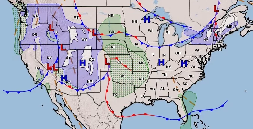
Having never seen the charts for the weather leading to an explosive eruption I can not say categorically that I am looking at one now but I have never seen a chart like this on:
https://data.consumer-digital.api.metoffice.gov.uk/v1/surface-pressure/colour/2023-11-17T0000/FSXX00T_00.gif
it looks to be full of thunder With black arcs in the spiral of what appears to Popocatapetl but the forecast goes on to show Iceland.
Ah well all I can do is put a marker here and hope for the best.I hope we are wrong but I don't think so. Good luck to all don't miss the warnings of tornadoes across the planet. Keep your faith up and your heads down.
A massive anticyclone is feeding what I take to be Nevado del Ruis and Pinatubo which "signal" is displaced to the south of Greenland. If there is anyone on here that is stupid enough to be following me on here you have as much faith as I do, you idiot.
Call on Jehovah he is waiting to hear from you.
On Friday, November 17, 2023 at 12:05:43 PM UTC, Mike wrote:idiot. I hope we are wrong but I don't think so. Good luck to all don't miss the warnings of tornadoes across the planet. Keep your faith up and your heads down.
Having never seen the charts for the weather leading to an explosive eruption I can not say categorically that I am looking at one now but I have never seen a chart like this on:This was the analysis chart form midnight the 17 November 2023
https://data.consumer-digital.api.metoffice.gov.uk/v1/surface-pressure/colour/2023-11-17T0000/FSXX00T_00.gif
it looks to be full of thunder With black arcs in the spiral of what appears to Popocatapetl but the forecast goes on to show Iceland.
Ah well all I can do is put a marker here and hope for the best.
A massive anticyclone is feeding what I take to be Nevado del Ruis and Pinatubo which "signal" is displaced to the south of Greenland. If there is anyone on here that is stupid enough to be following me on here you have as much faith as I do, you
which shows characteristics akin to the auroral emissions observed around planets like Earth, Jupiter, and Saturn, presents an unprecedented understanding of solar radio bursts and their potential link to similar phenomena in stars with large starspots.Call on Jehovah he is waiting to hear from you.Scientists are stupid: New Jersey Institute of Technology’s Center for Solar-Terrestrial Research (NJIT-CSTR) have documented an extraordinary aurora-like radio emission occurring approximately 25 000 miles above a sunspot. This novel radio emission,
The first thing an amateur though of this anomaly is that this is the same distance as the Moon is from Earth; therefore this is the distance socially speaking, the key. NJIT-CSTR has made a significant discovery in solar research an unusual type oflong-lasting polarized radio burst emanating from a sunspot, which persisted for over a week contrasting with typical transient solar radio bursts that usually last only minutes or hours. This discovery is pivotal, potentially reshaping our understanding
Aurora Borealis and Aurora Australis, occur when solar activities disturb Earth’s magnetosphere, leading to the precipitation of charged particles in the polar regions where they interact with atmospheric gases. These interactions generate intenseradio emissions at frequencies around a few hundred kHz. These emissions from electron-cyclotron maser (ECM) energetic electrons trapped within converging magnetic fields Cooler and intensely magnetic areas of sunspots, ideal environment for ECM
Necessarily linked to solar flares, they appear to be powered by sporadic flare activity in nearby regions, which injects energetic electrons into large-scale magnetic loops anchored at the sunspot. This results in the ECM radio emission above theregion.
This what i have been sayin iss the period when satellites pass each other's orbits. "sunspot radio aurora” seems to exhibit rotational modulation in sync with the solar rotation, creating a “cosmic lighthouse effect.” As the sunspot moves acrossthe solar disk, it generates a rotating beam of radio light, IOW: Torque modulated radio aurora observed from rotating stars. This phenomenon represents the first detection of its kind what did I tell you about stoopid?
Retrospective analyses to identify potential instances of this emission in previously recorded solar bursts. if the were not SFB they would have found it all by now.Chen, an associate professor of physics at NJIT-CSTR, is among the clearest evidence of radio ECM emissions seen from the sun, bearing resemblance to phenomena observed on our planets and distant stars.
Weaker than stellar auroral emissions observed in the past, these solar radio emissions are thought to be similar and may imply that starspots on cooler stars could be sources of certain radio bursts in various stellar environments. According to Bin
Edited for Stoopid
| Sysop: | Keyop |
|---|---|
| Location: | Huddersfield, West Yorkshire, UK |
| Users: | 546 |
| Nodes: | 16 (2 / 14) |
| Uptime: | 50:07:43 |
| Calls: | 10,397 |
| Calls today: | 5 |
| Files: | 14,067 |
| Messages: | 6,417,315 |
| Posted today: | 1 |